|
Calibrate Linear Scale
The Calibrate Linear Scale command works
interactively to calibrate a linear coordinate scale for the image.
The calibration is computed by drawing a line ("vector") of target
length and specifying the world coordinate units and distance along
the vector. The resulting calibration has equal scale in both x and
y coordinates and is saved to the image header as a
World Coordinate System. The coordinate units
are specified in the calibration dialog.
Procedure
-
Click the  button on the
Image Tools Toolbar or use the Coordinates > Calibrate Linear Scale menu
command. button on the
Image Tools Toolbar or use the Coordinates > Calibrate Linear Scale menu
command.
-
Immediately after this command is executed, the
following prompt is opened:
-
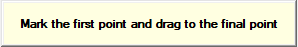
Mouse down at the fist point, drag to the final point, and release
the mouse button.
-
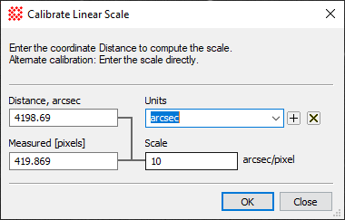
After releasing the button to complete the line, Mira opens the
Calibrate Linear Scale dialog shown below.
-
After clicking [OK], the world coordinate reference is set
to (0,0) at the image corner. Since pixel (1,1) occurs at the
center of the corner pixel, world coordinate (0,0) is
located at pixel coordinate (-0.5,-0.5).
|
Callibrate Llinear Scale Properties
|
|
Distance [units]
|
The distance in target coordinates corresponding
to the line drawn on the image. The name from the Units field is listed
in the caption. The example above shows the label Distance [units]
updated to Distance [arcsec] using the name specified in the
Units history box.
|
|
Units
|
The world coordinate units to use. You can choose
a value from the list box or enter units.
|
|
Measured [pixels]
|
Specifies the length of the line in units of image
[pixels].
|
|
Scale
|
This field reports the calculated image scale. You
can also override the calculated value by entering a replacement.
The name from the Units field is listed in the caption to the
right of the value.
|
This command applies a
World Coordinate System ("WCS") calibration to
the image or
image set to replace any existing WCS. The new
calibration may be reversed using
Edit > Undo (Ctrl+Z) to restore the previous coordinate
system. To permanently save the arcsecond calibration to the image
file, save the image in the normal way. You can repeat the
calibration any number of times without having to manually delete
the existing
World Coordinate System calibration. To delete
this or any other WCS calibration, use the
Delete WCS command.
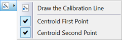
Command Properties
The Calibrate Linear
Scale command includes two properties that compute
subpixel-accurate centroid positions for the starting or ending
points of the mouse-drawn line. These are useful if the image
contains bright fiducial point markers for referenceing exact image
distance. These are set from the Calibrate
Linear Scale drop menu next to the command button on the Image
Measurement toolbar. The centroid parameters use values from
the
Centroid Properties dialog for the
Image Window. The Draw
Calibration Line command duplicates the function of the
command button.
Related Topics
Coordinate Systems
Set Linear Scale
Set Equatorial Scale
World Coordinate System
Mira Pro x64 8.67 User's Guide, Copyright Ⓒ 2023 Mirametrics, Inc.
All Rights Reserved.
|

