![]() Region
Measurements
Region
Measurements
The Region Measurement tool computes the area, perimeter, and luminance properties of polygons drawn on an image. The metric results are reported in both pixel coordinates and world coordinates (if the image has a world coordinate calibration). This command allows measuring any number of regions on 1 or more images in an image set.
To activate the Region Measurement tool,
click ![]() on the Main Toolbar or click
Regions in the Measure menu.
on the Main Toolbar or click
Regions in the Measure menu.
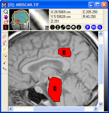
The screen capture below shows two free-hand regions marked on an image. The results of region measurements are listed in a Report window, as shown further below.
Three region types are available for marking regions:
Region Marker Types
|
Irregular Polygon |
The region is defined by a small number of connected line segments, each connected at a vertex. Regions are marked by clicking on vertex points |
|
Rectangular |
Each region is a rectangle of arbitrary shape. Regions are marked by rubberbanding from opposite corners. |
|
Free-hand |
The region outline appears as a continuous curve(see above). |
|
|
|
For a comparison of the region types, see Comparison of Region Marking Methods.
Each of the region types uses a different marking protocol. These are described in the measuring procedures on the following pages:
Rectangular Region Measurement
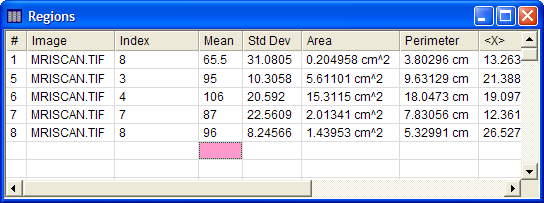
Measurements are tabulated in the Regions window as shown below. This is a Report Window with built-in functionality for sorting, rearranging, copying, saving, and other actions. Multiple images may be measured as an image set or by opening the Region Measurement Toolbar in multiple image windows. All measurements are reported in the same Regions window. Some data columns are scrolled beyond the right margin of the window.
Measurements for all objects in all images and all Image windows go into a single Report window. If you want to clear the Report window of prior measurements, make sure the window has focus, then click the View > Clear command.
The items in the Regions report are described in the table below.
Region Measurement Quantities
|
# |
The sequence number of the measurement. |
|
Image |
The name of the image that was measured. |
|
Index |
The marker index for the particular image. |
|
Mean |
The mean luminance value inside the region. |
|
Std Dev |
The standard deviation of the luminance values inside the region. |
|
Area |
The area of the region measured in world coordinates. If a world coordinate calibration does not exist, the the area is measured in square pixel units. |
|
Perimeter |
The perimeter of the region measured in world coordinates. If a world coordinate calibration does not exist, the perimeter is measured in pixel length units. |
|
<X> |
The luminance-weighted mean position of the region in the X direction, measured in world coordinates if the image has a World Coordinate Calibration. If the image does not have a WCS calibration, this is the column coordinate. |
|
<Y> |
The luminance-weighted mean position of the region in the Y direction, measured in world coordinates if the image has a World Coordinate Calibration. If the image does not have a WCS calibration, this is the row coordinate. |
|
<Col> |
The luminance-weighted mean column position of the region in the X direction, measured in pixel coordinates. |
|
<Row> |
The luminance-weighted mean row position of the region in the Y direction, measured in pixel coordinates. |
|
|
|
Measuring Images, Report Windows, Region Preferences, World Coordinate System