This command is executed from the ![]() button on the Measurement Toolbar
or by using the View > Coordinates menu.
button on the Measurement Toolbar
or by using the View > Coordinates menu.
Calibrate Linear Scale
The Calibrate Linear Scale command works interactively to calibrate a linear pixel scale for the image. This is done by drawing a line of known length and then specifying the coordinate units and the corresponding distance in those units. The resulting calibration is saved in the image header as a World Coordinate System.
This command is executed from the ![]() button on the Measurement Toolbar
or by using the View > Coordinates menu.
button on the Measurement Toolbar
or by using the View > Coordinates menu.
Initially, this command opens the prompt shown below which instructs you to mark the line:
![]()
After you finish marking the line and release the mouse button, Mira opens the Spatial Calibration dialog shown below:
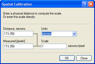
Parameters
|
Distance (units) |
The distance in target coordinates corresponding to the line drawn on the image. The name from the Units field is listed in the caption. |
|
Units |
The world coordinate units to use. You can choose a value from the list box or enter units. Be aware that a long unit name may appear truncated in the real-time coordinate readout of the Image Toolbar. |
|
Measured [pixels] |
Specifies the length of the line in units of image pixels. |
|
Scale |
Soecifies the calculated image scale. The name from the Units field is listed in the caption to the right of the value. |
This command applies a World Coordinate System ("WCS") calibration to the image or image set. This calibration replaces any existing WCS. The calibration applies only to the image in memory and does not become permanently affixed to the image until you save the image to a file. This command creates an Undo copy so that you can use the Edit > Undo (Ctrl+Z) command to restore the previous coordinate system. After clicking [OK] or [Apply], the world coordinate reference is set to (0,0) at the image edge. Since pixel (1,1) occurs at the center of the corner pixel, world coordinate (0,0) is occurs at pixel coordinate (-0.5,-0.5).
To use this command, you must know the world coordinate distance between two points on the image. You will then mark a line between those two points and enter the coordinate distance and units for the line.
Execute this command. A prompt opens below the image (see above).
Mouse down at the starting point of the line. Do not release the mouse button.
Move the mouse to the end point of the calibration line and releasae the mouse button.
In the Spatial Calibration dialog, enter the world coordinate units and the actual distance in those units.
Click [OK] to accept the calibration.
You can repeat the calibration any number of times without having to manually delete the existing calibration (see the Delete Calibration command).
Set Linear Scale, Set Equatorial WCS, World Coordinate System